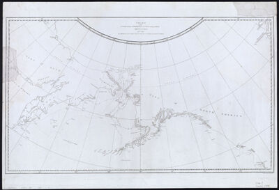
Chart of the NW Coast of America and NE Coast of Asia explored in the years 1778 & 1779. The unshaded parts of the coast of Asia are taken from a MS chart received from the Russians.
Collection: Osher Collection
Name: Chart of the NW Coast of America and NE Coast of Asia explored in the years 1778 & 1779. The unshaded parts of the coast of Asia are taken from a MS chart received from the Russians.
Barcode: 858
Creator: Cook, James, 1728-1779
Printmaker: Harmar, T.
From Atlas: No
Notes: Note at bottom right below map "Writing engraved by T. Harmar."
Date/Date Range Produced: 1784
Date/Date Range Published: 1784
Language: English
Region Depicted: AlaskaAleutian Islands (Alaska)AsiaBering SeaCanadaNorth AmericaPacific OceanRussia
Map Type: GeographicalNautical charts
Dimensions: 39 x 67 cm. on sheet 47 x 69 cm.
Printing Process: Engraving
Printing Technique: Copper
Material Type: Paper
OCLC: 221414671
Accession Number: OS-1784-7
Donor: Osher
Subjects: AlaskaAsiaBering SeaCanadaExploration and discoveryExplorersMaps--Early works to 1800Nautical chartsNorth AmericaPacific OceanRussia
Permenant URL: https://oshermaps.org/map/858.0001