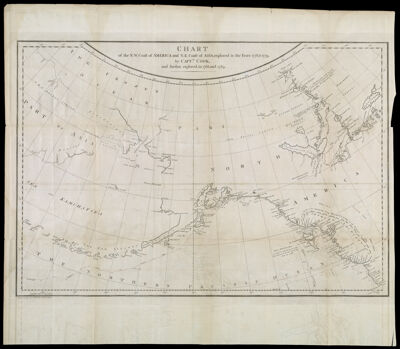
Chart of the N.W. Coast of America and N.E. Coast of Asia, explored in the years 1778, & 1779, by Captn. Cook, and further explored in the years 1788, and 1789
Collection: Osher Collection
Name: Chart of the N.W. Coast of America and N.E. Coast of Asia, explored in the years 1778, & 1779, by Captn. Cook, and further explored in the years 1788, and 1789
Barcode: 873
Creator: Haywood, JamesMeares, John, 1756?-1809
From Atlas: No
Notes: Note below neat line: "J. Haywood, del. No. 3 St. Martins Church Yard."
Date/Date Range Produced: 1790
Date/Date Range Published: 1790
Language: English
Region Depicted: AlaskaAleutian Islands (Alaska)AsiaBering SeaCanadaNorth AmericaPacific OceanRussia
Map Type: GeographicalNautical charts
Dimensions: 43 x 63 cm. on sheet 56 x 66 cm.
Printing Process: Engraving
Printing Technique: Copper
Material Type: Paper
LC Call Number:
OCLC:
Donor: Osher
Subjects: AlaskaAleutian Islands (Alaska)AsiaBering SeaCanadaCoastsExploration and discoveryExplorersMaps--Early works to 1800Nautical chartsNorth AmericaPacific OceanRussia
Permenant URL: https://oshermaps.org/map/873.0001