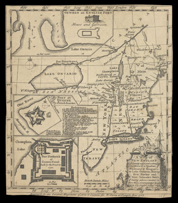
A Map of New England & ye Country adjacent, extending Northward to Quebec, & Westward to Niagara, on Lake Ontario: shewing Gen: Shirley and Gen: Iohnson's Routs, & many places omitted in other Maps: Communicated by a gentleman who resided in these parts.
Collection: Osher Collection
Name: A Map of New England & ye Country adjacent, extending Northward to Quebec, & Westward to Niagara, on Lake Ontario: shewing Gen: Shirley and Gen: Iohnson's Routs, & many places omitted in other Maps: Communicated by a gentleman who resided in these parts.
Barcode: 699
Creator: General Magazine of Arts and Science
From Atlas: No
Notes: Below neatline: "Engrav'd for the General Magazine of Arts & Sciences for W. Owen at Temple Bar 1755."
Publisher: General Magazine of Arts and Science
Purveyor: Owen, W. (William), -1793
Date/Date Range Produced: 1755
Date/Date Range Published: 1755
Language: English
Region Depicted: CanadaConnecticutMaineMassachusettsNew EnglandNew HampshireNew JerseyNew York (State)OntarioRhode IslandVermont
Map Type: Historical mapsThematic maps
Dimensions: H 21 x W 18 cm.
Printing Process: Engraving
Printing Technique: Copper
Material Type: Paper
LC Call Number:
OCLC: 810111326
Donor: Osher
Subjects: CanadaColonial AmericaConnecticutJohnson, William, 1715-1774MaineMaps--Early works to 1800MassachusettsMonumentsNew EnglandNew FranceNew HampshireNew JerseyNew York (State)OntarioplantsQuebec (Province)Rhode IslandSailing shipsShirley, William, 1694-1771TreesUnited States --History --French and Indian War, 1754-1763Vermont
Permenant URL: https://oshermaps.org/map/699.0001