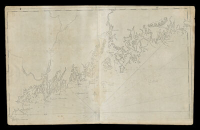
Untitled Chart of the Coast of Maine
Collection: Osher Collection
Name: Untitled Chart of the Coast of Maine
Barcode: 878
Creator: Anonymous / Unknown Author
From Atlas: No
Publishing Location: Boston (Mass.)
Notes: State 1; The Seconds State, 1801, is titled: A Chart of the Coast of America from WoodMap shows islands, bays, harbours and other landmarks: East Point Fletchers Neck; Wood Island; Sacco River; Richmond Island; Cape Elizabeth; Falmouth Harbour; Green Island; Drunken Ledges; Casco Bay; Halfway Rock; Baleys Island; Merriconneg Neck; Jebaleadigin; Sagedehoc River; Glovers Rock; Cape Small Point; Segwine Island; Bantain Islands; Parkers Island; Damiscove Island; Arowsick Island; Sheepscutt River; Jermisquam Island; Back River; Ovens Mouth; Damoriscotti River; Pemaquid Point; Johns Bay; Long Cove; Lavis Island; Hungry Island; Broad Bay; Madumcook Harbour; Burnet Island; St. George's Island; George's Harbour; Old Man; Muscater Island; Moore Point; Western Triangles; Matinic Isle; Green Island; Eastern Triangles; Tenants Harbour; Seal Harbour; St. Georges River; Madam Beatrix Mountains; Owls Head Island; Owls Head; Owls Head Bay; Clam Cove; Goose River; Northern Fox Island; Southern Fox Island; Megunticook Harbour; Penobscot Hills; Duck Trap; Winslow's Island; Belfast Bay; Brigadier Island; Penobscot River; Fort Pownal; Biggaduce; Cape Rose; Little Deer Island; Eggemoggin Reach; Deer Island; Penobscot Bay; Isle au Haut; Mount Desert Rock; Marshalls Island; Burntcoat Island; Nasheig Point; Blue Hills Bay; Long Island; Bartlett Island; Mount Desert Island; Tauntoll Bay; Frenchman's Bay; Skutock Hills; Scoodice Point; Goulsboro Harbour; Dyers or East Bay; Petitmenans Point; Petitmenans Island; Narraguagus River; Great Marsh River; Pleasant River; Cape Split; Moore Peck Reach; Mark Island; Good Harbour.
Publisher: Norman, John, 1748?-1817
Date/Date Range Produced: 1791
Date/Date Range Published: 1791
Language: English
Region Depicted: Maine
Map Type: Nautical charts
Dimensions: H 53.8 X W 84 cm
Printing Process: Engraving
Printing Technique: Copper
Material Type: Paper
LC Call Number:
OCLC: 871174420
Donor: Osher
Subjects: Androscoggin River (N.H. and Me.)Fort Western (Augusta, Me.)Kennebec River (Me.)Maps--Early works to 1800Nautical chartsPenobscot River (Me.)
Permenant URL: https://oshermaps.org/map/878.0001