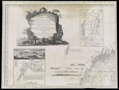
A New and Correct Chart of the Coast of New England and New York with the adjacent parts of Nova Scotia and New Brunswick, from Cape Sable to the entrance of Hudsons or Northriver by Captain Holland. London. Published by Laurie & Whittle, Fleet Street, as the Act directs, XXI. of May MDCCXCIV.
Collection: Osher Collection
Name: A New and Correct Chart of the Coast of New England and New York with the adjacent parts of Nova Scotia and New Brunswick, from Cape Sable to the entrance of Hudsons or Northriver by Captain Holland. London. Published by Laurie & Whittle, Fleet Street, as the Act directs, XXI. of May MDCCXCIV.
Barcode: 879
Creator: Holland, Samuel, 1728-1801
From Atlas: No
Notes: This is one map on 4 equal sized sheets.
Publisher: Laurie & Whittle
Date/Date Range Produced: 1794
Date/Date Range Published: 1794
Language: English
Region Depicted: ConnecticutLong Island, New YorkMaineMassachusettsNew HampshireNew York (State)Nova ScotiaRhode IslandVermont
Map Type: Nautical charts
Dimensions: 4 sheets: each 54 x 72 cm.
Printing Process: Engraving
Printing Technique: Copper
Material Type: Paper
LC Call Number:
OCLC:
Donor: Osher
Subjects: AnchorsBarrelsBoxesCartouches, Ornamental (Decorative arts)CoastsConnecticutCratesFishFishingFishing netsLaurie & WhittleMaineMaps--Early works to 1800MassachusettsNautical chartsNew HampshireNew York (State)Nova Scotia (Canada)plantsRhode IslandRocksSailing shipsTreesVermont
Permenant URL: https://oshermaps.org/map/879.0001; 879.0002; 879.0003; 879.0004