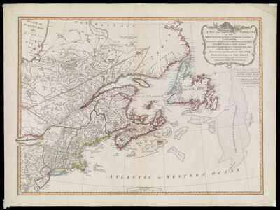
A New and Correct Map of the British Colonies in North America comprehending Eastern Canada with the Province of Quebec, New Brunswick, Nova Scotia, and the Government of Newfoundland: with the adjacent states of New England, Vermont, New York, Pennsylvania and New Jersey.
Collection: Osher Collection
Name: A New and Correct Map of the British Colonies in North America comprehending Eastern Canada with the Province of Quebec, New Brunswick, Nova Scotia, and the Government of Newfoundland: with the adjacent states of New England, Vermont, New York, Pennsylvania and New Jersey.
Barcode: 888
Creator: Laurie & Whittle
From Atlas: No
Notes: Note: "London. Published by Laurie & Whittle 53 Fleet Street, 12th May, 1794."
Publisher: Laurie & Whittle
Date/Date Range Produced: 1794
Date/Date Range Published: May 12th, 1794
Language: English
Region Depicted: ConnecticutEastern CanadaMaineMaritime ProvincesMassachusettsNew EnglandNew HampshireNew JerseyNew York (State)Newfoundland and LabradorNova ScotiaPennsylvaniaRhode IslandVermont
Map Type: GeographicalPolitical maps
Dimensions: H 54.5 x W 73 cm
Printing Process: Engraving
Printing Technique: Copper
Material Type: Paper
LC Call Number:
OCLC: 456400343
Donor: Osher
Subjects: AnimalsBeaversCanada, EasternCartouches, Ornamental (Decorative arts)ConnecticutLaurie & WhittleMaineMaps--Early works to 1800Maritime ProvincesMassachusettsNew EnglandNew HampshireNew JerseyNew York (State)Newfoundland and LabradorNova Scotia (Canada)PennsylvaniaQuebec (Province)Rhode IslandScrollworkVermont
Permenant URL: https://oshermaps.org/map/888.0001