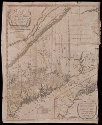
Map of the District of Maine Drawn from the Latest Surveys and Other Best Authorities of Osgood Carleton
Collection: Osher Map Library Collection
Name: Map of the District of Maine Drawn from the Latest Surveys and Other Best Authorities of Osgood Carleton
Barcode: 54234
Creator: Carleton, Osgood, 1742-1816
From Atlas: Yes
Publishing Location: Boston (Mass.)
Notes: Removed from "History of the District of Maine" [Barcode: 14991]Note lower right: "A Map of those parts of the Country most famous for being harrased by the Indians, on and long after their first settlement; and more particularly treated of in Judge Sullivan's History of the District of Maine"Note at top: "Engraved for Judge Sullivan's History of the District of Maine, published by Thomas & Andrews, Boston 1795."Includes bibliographical references to land grants.
Publisher: Thomas & Andrews
Date/Date Range Produced: 1795
Date/Date Range Published: 1795
Language: English
Region Depicted: Eastern CanadaMaineNew BrunswickNew EnglandQuébec City, CanadaQuébec, Canada
Map Type: Boundary mapsHistorical maps
Dimensions: 35 x 28 cm
LC Call Number: G3730 1795 .C3
OCLC: 6610133
Subjects: Colonial AmericaColonial settlements in AmericaMaine
Permenant URL: https://oshermaps.org/map/54234.0001