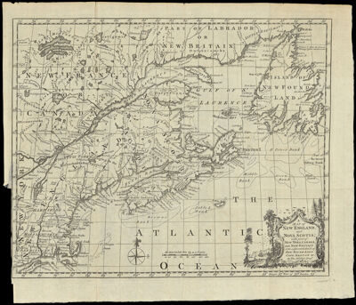
A Map Of New England, and Nova Scotia, with part of New York, Canada, and New Britain & the adjacent Islands of New Found Land Cape Breton & c. By Tho. Kitchin Geogr.
Collection: Osher Collection
Name: A Map Of New England, and Nova Scotia, with part of New York, Canada, and New Britain & the adjacent Islands of New Found Land Cape Breton & c. By Tho. Kitchin Geogr.
Barcode: 715
Creator: Kitchin, Thomas, 1718-1784
From Atlas: No
Notes: From: London Magazine, v. 27, 1758.
Publisher: London Magazine
Date/Date Range Produced: 1758
Date/Date Range Published: 1758
Language: English
Region Depicted: CanadaConnecticutLong Island, New YorkMaineMaritime ProvincesMassachusettsNew EnglandNew HampshireNew York (State)Newfoundland and LabradorNova ScotiaOntarioRhode IslandVermont
Map Type: GeographicalPolitical maps
Dimensions: H 30.8 x W 36.2 cm
Printing Process: Engraving
Printing Technique: Copper
Material Type: Paper
LC Call Number:
OCLC: 244678929
Donor: Osher
Subjects: CanadaColonial AmericaConnecticutHarborsLong Island (N.Y.)MaineMaps--Early works to 1800Maritime ProvincesMassachusettsNew EnglandNew HampshireNew York (State)Newfoundland and LabradorNova Scotia (Canada)OntarioplantsQuebec (Province)Rhode IslandSailing shipsTreesVermont
Permenant URL: https://oshermaps.org/map/715.0001