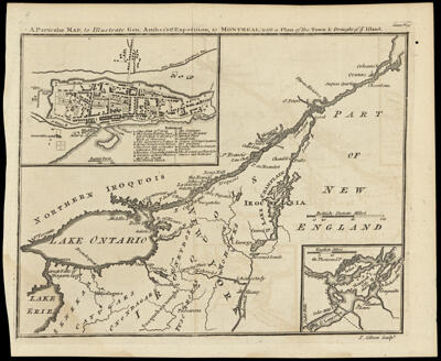
A Particular Map, to Illustrate Gen. Amherst's Expedition, to Montreal, with a Plan of the Town & Draught of ye Island.
Collection: Osher Collection
Name: A Particular Map, to Illustrate Gen. Amherst's Expedition, to Montreal, with a Plan of the Town & Draught of ye Island.
Barcode: 723
Creator: Gibson, J. (John), active 1750-1792
Printmaker: Gibson, J. (John), active 1750-1792
From Atlas: No
Notes: Note in lower right corner: "J. Gibson Sculpt."
Publisher: Gentleman's magazine (London, England)
Date/Date Range Produced: 1760
Date/Date Range Published: 1760
Language: English
Region Depicted: New York (State)OntarioSaint Lawrence River Valley
Map Type: GeographicalPolitical maps
Dimensions: H 20.5 x W 24.7 cm
Printing Process: Engraving
Printing Technique: Copper
Material Type: Paper
LC Call Number: G1144 .G53 1760
OCLC: 52137489
Donor: Osher
Subjects: Colonial AmericaGentleman's magazine (London, England)Indians of North AmericaMaps--Early works to 1800Native AmericansNew York (State)OntarioSaint Lawrence River Valley
Permenant URL: https://oshermaps.org/map/723.0001