Maine.
Collection: Osher Collection
Name: Maine.
Barcode: 1092
Creator: Anonymous / Unknown Author
Printmaker: Fisk & Russell
From Atlas: Yes
Publishing Location: New York
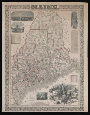
Notes: Notes: "Fisk & Russell, relief plate map engravers, N.Y."Insets images: "Shipping Lumber"; "View of Bangor"; "Lumbering"; "Seal of the State of Maine"; "Agriculture".Left side contains list of Governors from 1820 - 1860.Right side has history and "date of organization of counties".
Publisher: Ensign, Bridgman & Fanning
Date/Date Range Produced: 1860
Date/Date Range Published: 1860
Language: English
Region Depicted: Maine
Map Type: GeographicalPolitical maps
Dimensions: 77 x 55 cm.
Material Type: Paper
LC Call Number: G3730 .E6 1860
OCLC: 54995862
Accession Number: OS-1860-12
Donor: Osher
Subjects: AgricultureAnimalsBarnsBuildingsCountiesDwellingsEmblemsEnsign, Bridgman & FanningFarmersFencesFisk & RussellHayHorsesIndians of North AmericaIndigenous peopleLumberLumberingMaine--MapsMooseMountainsNative AmericansOxenRailroadsRivers and lakesSailing shipsWagons
Permenant URL: https://oshermaps.org/map/1092.0001