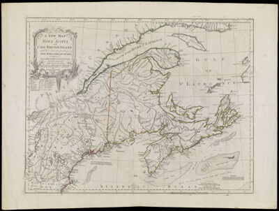
A New Map of Nova Scotia, and Cape Breton Island with the adjacent parts of New England and Canada, Composed from a great number of actual Surveys, and other materials Regulated by many new Astronomical Observations of the Longitude as well as Latitude: by Thomas Jefferys, Geographer to the King., copy 1
Collection: Osher Collection
Name: A New Map of Nova Scotia, and Cape Breton Island with the adjacent parts of New England and Canada, Composed from a great number of actual Surveys, and other materials Regulated by many new Astronomical Observations of the Longitude as well as Latitude: by Thomas Jefferys, Geographer to the King., copy 1
Barcode: 779
Creator: Jefferys, Thomas, 1710-1771
From Atlas: No
Notes: Copy 1. Note above lower neat line: " Published according to Act of Parliament by Thos. Jefferys, Geographer to the King" Note below neat line: "London, Printed & Sold by R. Sayer & J. Bennett, No. 53 in Fleet Street 15 June 1775."
Publisher: Robert Sayer and John Bennett (Firm)
Purveyor: Robert Sayer and John Bennett (Firm)
Date/Date Range Produced: 1775
Date/Date Range Published: Jun 15th, 1775
Language: English
Region Depicted: CanadaMaineMaritime ProvincesMassachusettsNew EnglandNew HampshireNova ScotiaVermont
Map Type: GeographicalPolitical maps
Dimensions: 47 x 62 cm. on sheet 55 x 74 cm.
Printing Process: Engraving
Printing Technique: Copper
Material Type: Paper
LC Call Number:
OCLC: 5409028
Donor: Osher
Permenant URL: https://oshermaps.org/map/779.0001