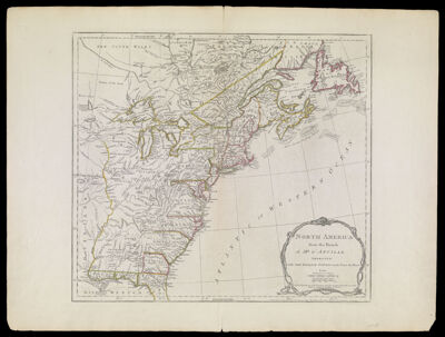
North America from the French of Mr. D'Anville Improved with the English Surveys made Since the Peace
Collection: Osher Collection
Name: North America from the French of Mr. D'Anville Improved with the English Surveys made Since the Peace
Barcode: 782
Creator: Array
Printmaker: Sayer, Robert, 1725-1794
From Atlas: Yes
Notes: Note on bottom right: "London Printed for Robt. Sayers & J. Bennett, Map & Printsellers, No. 53 Fleet Street as the Act directs 10 June 1775." From Thomas Jefferys' American Atlas.
Atlas Reference: The American Atlas, 1775
Publisher: Robert Sayer and John Bennett (Firm)
Purveyor: Robert Sayer and John Bennett (Firm)
Date/Date Range Produced: 1775
Date/Date Range Published: Jun 1775
Language: English
Region Depicted: AlabamaArkansasConnecticutDelawareEastern CanadaFloridaGeorgiaIllinoisIndianaIowaKentuckyLouisianaMaineMarylandMassachusettsMichiganMinnesotaMississippiMissouriNew HampshireNew JerseyNew York (State)Newfoundland and LabradorNorth CarolinaNova ScotiaOhioOntarioPennsylvaniaRhode IslandSouth CarolinaTennesseeVermontVirginiaWest VirginiaWisconsin
Map Type: GeographicalPolitical maps
Dimensions: 46 x 51 cm. on sheet 56 x 74 cm.
Printing Process: Engraving
Printing Technique: Copper
Material Type: Paper
LC Call Number:
OCLC: 5406791
Donor: Osher
Permenant URL: https://oshermaps.org/map/782.0001