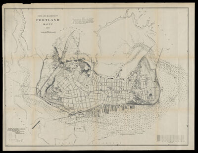
City and Harbor of Portland Maine 1870
Collection: Osher Collection
Name: City and Harbor of Portland Maine 1870
Barcode: 1132
Creator: United States Coast Survey
From Atlas: No
Notes: Note: "This map is reduced from surveys made in 1868 & 69 for the city of Portland under the direction of Benjamin Peirce, superintendent U.S. Coast Survey by assistants H. L. Whiting, J. A. Sullivan, A. Lindenkohl, J. W. Donn, C. Hosmer and H. Anderson. The manuscript maps on a scale of 100 feet to the inch are in the possession of the city of Portland."
Publisher: United States Coast Survey
Surveyor: Peirce, Benjamin, 1809-1880
Date/Date Range Produced: 1870
Date/Date Range Published: 1870
Language: English
Region Depicted: Portland Harbor, Maine
Map Type: City mapsNautical chartsTopographical maps
Dimensions: H 61.5 x W 80 cm
Material Type: Paper
LC Call Number: G3734.P8 P5 1870
OCLC: 70868058
Donor: Osher
Subjects: HarborsHarborsMaineMaine--MapsNautical chartsNautical chartsPortland (Me.)Portland Harbor, MainePortland Harbor, MainePortland, MaineUnited States Coast SurveyUnited States Coast Survey
Permenant URL: https://oshermaps.org/map/1132.0001