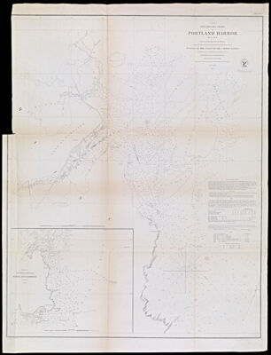
(A No. 3) Preliminary Chart of Portland Harbor Maine from a Trigonometrical Survey under the direction of A.D. Bache Superintendent of the Survey of the Coast of the United States Triangulation by C.O. Boutelle Assistant U.S.C.S. Topography by A.W. Longfellow Assist. Hydrography by the Party under the command of Lieut. M. Woodhall U.S.N. Assist
Collection: Osher Collection
Name: (A No. 3) Preliminary Chart of Portland Harbor Maine from a Trigonometrical Survey under the direction of A.D. Bache Superintendent of the Survey of the Coast of the United States Triangulation by C.O. Boutelle Assistant U.S.C.S. Topography by A.W. Longfellow Assist. Hydrography by the Party under the command of Lieut. M. Woodhall U.S.N. Assist
Barcode: 1055
Creator: Array
Printmaker: Array
From Atlas: No
Publishing Location: Washington D.C.
Notes: Note: "Eng'd. by J. Knight, J.V.N. Throop and G.B. Metzeroth."Inset included: Sketch of Approaches to Portland Harbor.
Publisher: United States Coast Survey
Surveyor: Bache, A. D. (Alexander Dallas), 1806-1867
Date/Date Range Produced: 1854
Date/Date Range Published: 1854
Language: English
Region Depicted: Portland Harbor, Maine
Map Type: Nautical charts
Dimensions: H 74.3 x W 56.7 cm
Material Type: Paper
LC Call Number:
OCLC: 173644960
Donor: Osher
Subjects: Bache, A. D. (Alexander Dallas), 1806-1867CoastsIslandsMaine--MapsNautical chartsPortland (Me.)Portland Harbor, MaineUnited States Coast Survey
Permenant URL: https://oshermaps.org/map/1055.0001