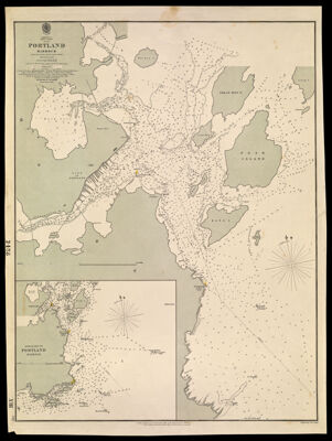
America East Coast Portland Harbour From the United States Coast Survey Published in 1854
Collection: Osher Collection
Name: America East Coast Portland Harbour From the United States Coast Survey Published in 1854
Barcode: 1082
Creator: J. & C. Walker (Firm)
Printmaker: J. & C. Walker (Firm)
From Atlas: No
Notes: Notes below the neat line: "London, Published at the Hydrographic Office of the Admiralty Jany. 13th 1857. Sold by J.D. Potter Agent for the Admiralty Charts 31 Poultry & H King St. Tower Hill." "Engraved by J. & C. Walker."
Publisher: Admiralty marine science publication
Purveyor: Potter, J. D. (John Dennett), active 1830-1892
Date/Date Range Produced: 1857
Date/Date Range Published: Jan 13th, 1857
Language: English
Region Depicted: Portland Harbor, Maine
Map Type: Nautical charts
Dimensions: H 67.5 x W 50.2 cm
Material Type: Paper
LC Call Number: TC203.P55 P8 1857
OCLC: 55520553
Donor: Osher
Subjects: HarborsNautical charts
Permenant URL: https://oshermaps.org/map/1082.0001