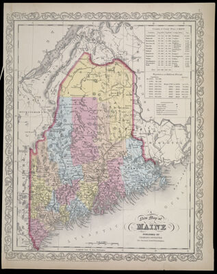
A New Map of Maine Published by Charles Desilver 714 Chestnut Street Philadelphia
Collection: Osher Collection
Name: A New Map of Maine Published by Charles Desilver 714 Chestnut Street Philadelphia
Barcode: 1090
Creator: Anonymous / Unknown Author
From Atlas: Yes
Publishing Location: Philadelphia
Notes: Note: " "Entered according to Act of Congress in the year 1860. by Charles Desilver in the Clerks office of the District Court of the Eastern District of Pennsylvania." "7." in upper right corner of sheet.Information about populations from years 1765 -1850 and every ten years between them is included in the top right corner.
Publisher: Desilver, Charles
Date/Date Range Produced: 1860
Date/Date Range Published: 1860
Language: English
Region Depicted: Maine
Map Type: GeographicalPolitical maps
Dimensions: H 38 x W 30 cm
Material Type: Paper
LC Call Number: G3430 .D47 1860
OCLC: 54525145
Donor: Osher
Subjects: CanalsCountiesMaine--MapsMountainsRailroadsRivers and lakes
Permenant URL: https://oshermaps.org/map/1090.0001