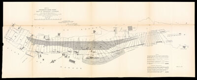
Sheet No. I Penobscot River, Maine. Map of Bangor Harbor, from survey made under the direction of Lieut.-Col., Jared A. Smith, Corps of Engineers, U.S. Army, In accordance with River and Harbor Act dated September 19th, 1890 By A.C. Roth, Assistant Engineer October 1891
Collection: Osher Collection
Name: Sheet No. I Penobscot River, Maine. Map of Bangor Harbor, from survey made under the direction of Lieut.-Col., Jared A. Smith, Corps of Engineers, U.S. Army, In accordance with River and Harbor Act dated September 19th, 1890 By A.C. Roth, Assistant Engineer October 1891
Barcode: 1266
Creator: Smith, Jared A. (Jared Augustine), 1840-1910United States. Army. Corps of Engineers.
From Atlas: No
Publishing Location: Portland (Me.)
Notes: Sheet 1 of a 3 part set of maps of the Penobscot River with OS-1891-76.2 and OS-1891-76.3 Includes printed document titled: "Penobscot River Maine...Letter from the Acting Secretary of War". Note: "U.S. Engineer Office Portland, Maine, November 28, 1891 Forwarded to the Chief of Engineers, U.S. Army with report of this date. Jared A. Smith Lieut.-Col. Corps of Engineers, U.S. Army."
Publisher: United States. Army. Corps of Engineers. Engineer Office
Date/Date Range Produced: 1892
Date/Date Range Published: 1892
Language: English
Region Depicted: Bangor, MaineBrewer, MainePenobscot River
Map Type: Nautical charts
Dimensions: H 32 x W 82 cm
Material Type: Paper
LC Call Number:
OCLC: 1004274239
See Also: Sheet No. II Map of Portion of Penobscot River, Maine between Stearn's Mill and Crosby's Narrows Showing Area under contract to be dredged in front of Stearn's Mill, also The condition of Shoal and the Location of two Jetties for contracting the channel above Crosby's Narrows.Sheet No. III Penobscot River, Maine - Plan of Resurvey of Channel below Winterport, also of Part of River, in the Vicinity of High Head. Made in September 1891, by A.C Roth, Assist. Engnr. under the direction of Lieut. Col. Jared A. Smith, Corps of Engineers, U.S. Army
Donor: Osher
Subjects: Bangor (Me.)Brewer (Me.)HarborsMaine--MapsNautical chartsPenobscot River (Me.)RiversUnited States. Army. Corps of Engineers
Permenant URL: https://oshermaps.org/map/1266.0001