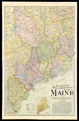
Scarborough's Complete Road Map of Southwest Maine showing Railroads, Electric Railways, Steamboat Lines, Highways, Post Offices, Villages, etc. with Complete Index.
Collection: Osher Collection
Name: Scarborough's Complete Road Map of Southwest Maine showing Railroads, Electric Railways, Steamboat Lines, Highways, Post Offices, Villages, etc. with Complete Index.
Barcode: 1338
Creator: Scarborough Company
From Atlas: No
Publishing Location: Indianapolis, IN.
Notes: Map folds into attached cover. Verso: Map index and natural features of area. Note: "Copyright, 1905, by The Scarborough Company, Indianapolis, Ind.""Information of Cities, Villages, Post-Offices, and Stations. With populations from 1900 census, and index to locations on map."Inset image: "Key Map, showing relation of large road map to the State of Maine, it's railways, etc."
Publisher: Scarborough Company
Date/Date Range Produced: 1905
Date/Date Range Published: 1905
Language: English
Region Depicted: Androscoggin County, MaineCumberland County, MaineFranklin County, MaineKennebec County, MaineKnox County, MaineLincoln County, MaineOxford County, MainePenobscot County, MainePiscataquis County, MaineSagadahoc County, MaineSomerset County, MaineWaldo County, MaineYork County, Maine
Map Type: Political mapsRoad maps
Dimensions: 116 x 75 cm. folded in covers 23 x 12 cm.
Material Type: Paper
LC Call Number:
OCLC: 824777203
Donor: Osher
Subjects: Androscoggin County (Me.)CensusCountiesCumberland County (Me.)Franklin County (Me.)Kennebec County (Me.)Knox County (Me.)LighthousesLincoln County (Me.)Maine--MapsOxford County (Me.)Penobscot County (Me.)Piscataquis County (Me.)RailroadsRoad mapsSagadahoc County (Me.)Scarborough CompanySomerset County (Me.)Steamboat linesStreet-railroadsTransportationWaldo County (Me.)York County (Me.)
Permenant URL: https://oshermaps.org/map/1338.0001; 1338.0002