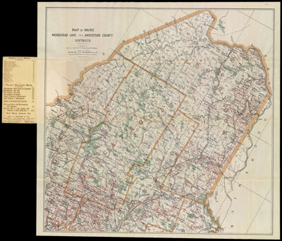
Map of Maine Moosehead Lake and Aroostook County Districts.
Collection: Osher Collection
Name: Map of Maine Moosehead Lake and Aroostook County Districts.
Barcode: 1343
Creator: Anonymous / Unknown Author
From Atlas: No
Publishing Location: Boston (Mass.)
Notes: Map folds into attached cover. Cover title: "Latest Map of the Moosehead Lake Region and Aroostook County, Maine Published by Geo. H. Walker & Co. Lithographers, 221 High St., near Rowes Wharf Boston Mass."
Publisher: Geo. H. Walker & Co.
Date/Date Range Produced: 1905
Date/Date Range Published: 1905
Language: English
Region Depicted: Aroostook County, MainePenobscot County, MainePiscataquis County, MaineSomerset County, Maine
Map Type: Boundary mapsGeographical
Dimensions: 57 x 58 cm. folds into cover 17 x 8 cm.
Material Type: Paper
LC Call Number:
OCLC:
Donor: Osher
Subjects: Aroostook County (Me.)LakesMaine--MapsMoosehead Lake (Me.)Penobscot County (Me.)Piscataquis County (Me.)RiversSomerset County (Me.)Washington County (Me.)Waterways
Permenant URL: https://oshermaps.org/map/1343.0001