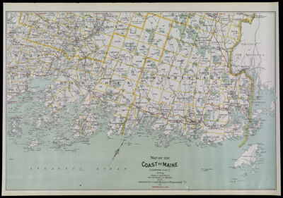
Map of the Coast of Maine (Eastern Part) published by Walker Lith. & Pub. Co. 400 Newbury St., Boston.
Collection: Osher Collection
Name: Map of the Coast of Maine (Eastern Part) published by Walker Lith. & Pub. Co. 400 Newbury St., Boston.
Barcode: 1344
Creator: Walker Lith. & Pub. Co.
From Atlas: No
Publishing Location: Boston (Mass.)
Notes: Notes stamped below title: "No. 46" "Best Routes shown in Red."
Publisher: Walker Lith. & Pub. Co.
Date/Date Range Published: 1895
Language: English
Region Depicted: Hancock County, MainePenobscot County, MaineWaldo County, Maine
Map Type: Political mapsRoad maps
Dimensions: H 57 x W 81.8 cm
Printing Process: Lithograph
Printing Technique: Planar Surface
Material Type: Paper
LC Call Number: G3732.W3 1905
OCLC: 880677481
See Also: Map of the Coast of Maine (Eastern Part)Map of the Coast of Maine (Eastern Part) published by Geo. H. Walker & Co. 221 High St., Boston.
Donor: Osher
Permenant URL: https://oshermaps.org/map/1344.0001