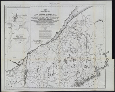
Map of the Boundary Lines Between the United States and the Adjacent British Provinces from the Mouth of the River St. Croix to the Intersection of the Parallel of 45 Degrees of North Latitude with the River St. Lawrence near St. Regis showing the Lines as respectively claimed by the United States and Great Britain under the Treaty of 1783 as awarded by the King of the Netherlands and as settled in 1842 by the Treaty of Washington.
Collection: Osher Collection
Name: Map of the Boundary Lines Between the United States and the Adjacent British Provinces from the Mouth of the River St. Croix to the Intersection of the Parallel of 45 Degrees of North Latitude with the River St. Lawrence near St. Regis showing the Lines as respectively claimed by the United States and Great Britain under the Treaty of 1783 as awarded by the King of the Netherlands and as settled in 1842 by the Treaty of Washington.
Barcode: 1285
Creator: Graham, J. D. (James Duncan), 1799-1865Lee, Thomas Jefferson, 1808-1891United States. Army. Corps of Engineers.
From Atlas: No
Publishing Location: Washington D.C.
Notes: Note above neat line: "Map G No. 3" Bottom left: "Printed by order of the Senate of the U.S. of March 3rd, 1843".
Date/Date Range Produced: 1843
Language: English
Region Depicted: MaineNew HampshireNew York (State)Vermont
Map Type: Boundary mapsGeographical
Dimensions: 57 x 69 cm.
Printing Process: Engraving
Printing Technique: Steel
Material Type: Paper
LC Call Number:
OCLC: 874924615
Accession Number: OS-1895-16
Donor: Osher
Subjects: BorderlandsNortheast boundary of the United StatesWebster-Ashburton Treaty (1842 August 9)
Permenant URL: https://oshermaps.org/map/1285.0001