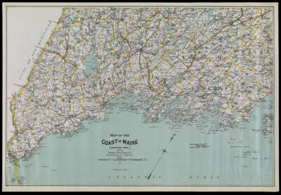
Map of the Coast of Maine (Western Part). Published by Walker Lith. & Pub. Co. 400 Newbury St., Boston.
Collection: Osher Collection
Name: Map of the Coast of Maine (Western Part). Published by Walker Lith. & Pub. Co. 400 Newbury St., Boston.
Barcode: 3863
Creator: Walker Lith. & Pub. Co.
From Atlas: No
Notes: Copy 1; Copy 2 is OS-1905-12. Cycling routes shown in red; Note: "Best Routes shown in Red."
Publisher: Walker Lith. & Pub. Co.
Date/Date Range Produced: 1905
Date/Date Range Published: 1905
Language: English
Region Depicted: Androscoggin County, MaineCumberland County, MaineKennebec County, MaineKnox County, MaineLincoln County, MaineOxford County, MaineSagadahoc County, MaineWaldo County, MaineYork County, Maine
Map Type: GeographicalPolitical maps
Dimensions: H 54.7 x W 80 cm
Material Type: Paper
LC Call Number: G3737 .C6 1905 .G3
OCLC: 32999278
Donor: Osher
Subjects: Androscoggin County (Me.)Cumberland County (Me.)Franklin County (Me.)Kennebec County (Me.)Knox County (Me.)Lincoln County (Me.)Oxford County (Me.)Sagadahoc County (Me.)Waldo County (Me.)York County (Me.)
Permenant URL: https://oshermaps.org/map/3863.0001