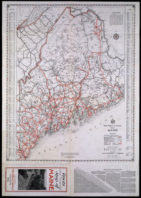
Maine Its Recreation and History
Collection: Osher Collection
Name: Maine Its Recreation and History
Barcode: 3980
Creator: Linscott, M. C.
From Atlas: No
Notes: Copy 2; Copy 1 is barcode 3978Folded title: "Route and Pictorial Map of Maine - Issued by the State Highway Commission Augusta, Me. 1935" M.C. Linscott. Map on verso: "State Highway Commission Map of Maine. Verso: "Index to cities and towns and mileage chart"
Publisher: Maine. State Highway Commission
Date/Date Range Produced: 1935
Date/Date Range Published: 1935
Language: English
Region Depicted: Maine
Map Type: GeographicalThematic maps
Dimensions: 65 x 46 cm.
Material Type: Paper
LC Call Number: G3731 .E63 1935 .L5
OCLC: 13787486
Donor: Osher
Subjects: AgricultureAnimalsAnimals, MythicalAquatic sportsAutomobilesBlueberriesBoats and boatingBuildingsCanoes and canoeingChurch buildingsCities and townsClamsDamsDivingDrivingDwellingsFish hatcheriesFishingFortificationGolfHikingHorsemanshipHorsesHuntingImaginary creaturesIndians of North AmericaIndigenous peopleJailsLighthousesLobster trapsLobstersLumberingMaineMaine--MapsMaine. State Highway CommissionMermaidsMining engineeringMooseMotorboat racingNative AmericansNaval battlesPaper millsPicnicsPictorial mapsPiersPiratesPotatoesPulp millsRadio and television towersRecreationSailing shipsShellsSwimmingTentsTunaUniversities and collegesWhales
Permenant URL: https://oshermaps.org/map/3980.0001; 3980.0002