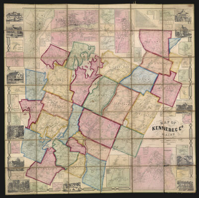
Map of Kennebec Co. Maine from actual surveys by Baker & Co. Published by J. Chace Jr. 17 & 19 Minor St. Philadelphia and Augusta Me. 1856.
Collection: Osher Collection
Name: Map of Kennebec Co. Maine from actual surveys by Baker & Co. Published by J. Chace Jr. 17 & 19 Minor St. Philadelphia and Augusta Me. 1856.
Barcode: 12490
Creator: Chace, J.
Publishing Location: Philadelphia
Notes: Several inset maps including China Village, City of Hallowell, East Vassalboro, and Readfield Corner.Includes illustrations of important buildings such as Waterville CollegeNote: "Entered according to Act of Congress, in the year 1856 by J. Chase Jr. in the Clerks Office of the District Court in the Eastern District of Pennsylvania"Sectioned and linen-backed
Publisher: Chace, J.
Surveyor: Baker & Co.Southwick, J.
Date/Date Range Produced: 1856
Date/Date Range Published: 1856
Language: English
Region Depicted: Kennebec County, Maine
Map Type: Wall maps
Dimensions: H 135 x W 136 cm
LC Call Number: G3733.K4 1856.S6
OCLC: 847787284
Donor: Osher
Subjects: Kennebec County (Me.)
Permenant URL: https://oshermaps.org/map/12490.0001