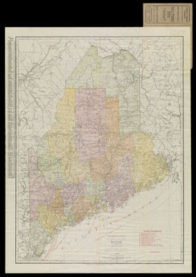
The Rand-McNally New Commercial Atlas Map of Maine
Collection: Osher Collection
Name: The Rand-McNally New Commercial Atlas Map of Maine
Barcode: 1404
Creator: Rand McNally and Company
From Atlas: No
Publishing Location: Chicago
Notes: Note below scale: "The Rand-McNally New Commercial Atlas Map of Maine. Copyright by Rand-McNally & Co. 1914" Note below neat line: "Rand McNally & Co., Map Publishers and Engravers, Chicago, 1914" Verso: Index titled "Maine. Counties, Islands, Lakes, Ponds, Rivers, and Towns."
Publisher: Rand McNally and Company
Date/Date Range Produced: 1912
Date/Date Range Published: 1912
Language: English
Region Depicted: Maine
Map Type: Boundary mapsPolitical mapsTransportation maps
Dimensions: 65 x 49 cm. on sheet 70 x 54 cm. folds in cover 14 x 7 cm.
Material Type: Paper
LC Call Number:
OCLC:
Donor: Osher
Subjects: MaineMaine--MapsRailroadsRand McNally and CompanySteamboat linesTransportation
Permenant URL: https://oshermaps.org/map/1404.0001; 1404.0002