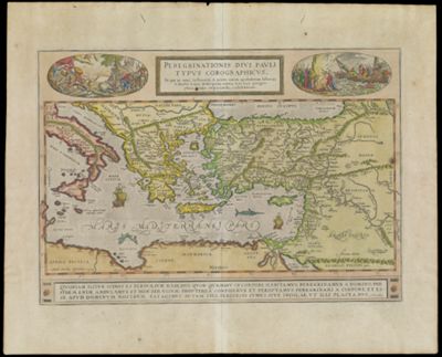
Peregrinationis divi Pauli Typus Corographicus. In qou et noui testamenti, in primis autem apostolorum historiae, a sancto Luca descriptae, omnia sere loca geographica, oculis inspicienda exhibentur.
Collection: Osher Collection
Name: Peregrinationis divi Pauli Typus Corographicus. In qou et noui testamenti, in primis autem apostolorum historiae, a sancto Luca descriptae, omnia sere loca geographica, oculis inspicienda exhibentur.
Barcode: 12820
Creator: Ortelius, Abraham, 1527-1598
From Atlas: Yes
Publishing Location: Antwerp
Notes: Shows scenes from the life of Saint Paul. Also shows the entire Eastern Mediterranean from Italy as far as Mesopotamia as travelled through by St. Paul. On both sides of the title cartouche are medallions depicting scenes from the life of St. Paul. At the bottom, a quote from Corinthians.
Publisher: Ortelius, Abraham, 1527-1598
Date/Date Range Produced: 1579
Date/Date Range Published: 1579
Language: Latin
Region Depicted: Mediterranean regionMediterranean Sea
Map Type: Chorographic mapsGeographicalHistorical mapsPolitical maps
Dimensions: 24 x 48 cm. on sheet 40 x 54 cm.
Printing Process: Engraving
Printing Technique: Copper
Material Type: Paper
LC Call Number: G7481.3 1579 O7
OCLC: 727797180
Donor: Osher
Subjects: Paul, the Apostle, Saint
Permenant URL: https://oshermaps.org/map/12820.0001; 12820.0002