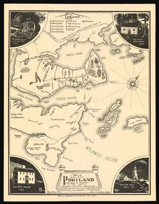
A Plan of Ancient Portland (then known as Falmouth) circa 1688 with Additions of Later Points of Historic Interest
Collection: Shettleworth Collection
Name: A Plan of Ancient Portland (then known as Falmouth) circa 1688 with Additions of Later Points of Historic Interest
Barcode: 3203
Creator: Gallagher, James H.
From Atlas: No
Publishing Location: Portland, ME
Notes: Engraved by James H. Gallagher. Printed by Ray Gailey.
Publisher: Gailey, Ray
Date/Date Range Produced: 1946
Date/Date Range Published: Dec 1946
Language: English
Region Depicted: Cape Elizabeth, MaineCasco Bay, MaineSouth Portland, Maine
Map Type: Historical maps
Dimensions: 53 x 42 cm
Material Type: Paper
LC Call Number: G3734.P9 G3 1946
OCLC: 173318958
Donor: Shettleworth
Subjects: BuildingsCape Elizabeth (Me.)Casco Bay (Me.)DwellingsExplorersHotelsLevett, Christopher, 1586-1630LighthousesLog cabinsPortland (Me.)Portland (Me.) --HistoryPortland Head Light, MaineSouth Portland (Me.)Tate House (Portland, Me.)Tate, George, 1700-1794Taverns (Inns)
Permenant URL: https://oshermaps.org/map/3203.0001