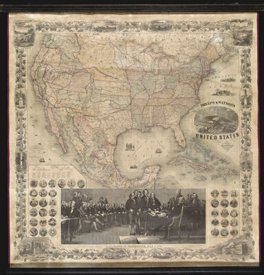
Phelps and Watson's New Map of the United States
Collection: Osher Collection
Name: Phelps and Watson's New Map of the United States
Barcode: 13129
Creator: Colton, G. Woolworth (George Woolworth), 1827-1901
Publishing Location: New York
Notes: Large picture of the signing of the Declaration of Independence below map.Includes illustrations of state seals, the signing of the Declaration of Independence, signature and profile of signers, and views in the border.
Date/Date Range Produced: 1860
Date/Date Range Published: 1860
Language: English
Dimensions: x
LC Call Number:
OCLC:
Donor: Osher
Permenant URL: https://oshermaps.org/map/13129.0001