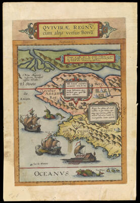
Qvivirae Regnv, cum alijs versus Borea
Collection: Osher Collection
Name: Qvivirae Regnv, cum alijs versus Borea
Barcode: 329
Creator: Jode, Cornelis de, 1568-1600
From Atlas: Yes
Publishing Location: Antwerp
Notes: Map depicting the west coast from below the Tropic of Cancer to the North Pole. There is also an early indication of the magnetic pole. Includes mythical creatures and ships.Verso: Text in Latin.
Date/Date Range Produced: 1593
Date/Date Range Published: 1593
Language: Latin
Region Depicted: AlaskaBritish ColumbiaNorth AmericaWestern CanadaWestern United StatesYukon Territory
Map Type: GeographicalPolitical maps
Dimensions: 35 x 25 cm. on sheet 42 x 28 cm.
Printing Process: Engraving
Printing Technique: Copper
Material Type: Paper
LC Call Number: G3350 1593 .J6
OCLC: 727806320
Donor: Osher
Subjects: AlaskaAnimalsBisonBritish ColumbiaCanada, WesternCattleDwellingsGalleonsGoatsImaginary creaturesImaginary placesIndigenous peopleJode, Cornelis de, 1568-1600Maps--Early works to 1800North AmericaNorth American faunaOrdnanceQuivira (Legendary place)Sailing shipsSea monstersTentsUnicornsWarshipsWest (U.S.)Yukon
Permenant URL: https://oshermaps.org/map/329.0001; 329.0002