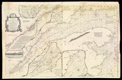
An Exact Chart of the River St. Laurence, from Fort Frontenac to the island of Anticosti shewing the Soundings, Rocks, Shoals &c with Views of the Lands and all necessary Instructions for navigating that River to Quebec.
Collection: Smith Collection
Name: An Exact Chart of the River St. Laurence, from Fort Frontenac to the island of Anticosti shewing the Soundings, Rocks, Shoals &c with Views of the Lands and all necessary Instructions for navigating that River to Quebec.
Barcode: 4737
Creator: Jefferys, Thomas, 1710-1771
From Atlas: Yes
Notes: Appears in Jeffery's "The American Atlas" 1775. Includes text. Note below neat line: "London, printed for Robt. Sayer Map & Printseller, No. 53, Fleet Street, as the Act directs. 25 May 1775."
Atlas Reference: The American Atlas, 1775
Subjects: Array
Publisher: Sayer, Robert, 1725-1794
Purveyor: Sayer, Robert, 1725-1794
Date/Date Range Produced: 1775
Date/Date Range Published: May 25th, 1775
Language: English
Region Depicted: New EnglandNova Scotia
Map Type: Nautical charts
Dimensions: H 63 x W 97.5 cm
Material Type: Paper
LC Call Number: G3312.S5P5 1775 .J4
OCLC: 5411776
Donor: Smith
Permenant URL: https://oshermaps.org/map/4737.0001