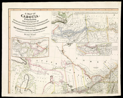
Map of Cabotia comprehending the provinces of Upper and Lower Canada, New-Brunswick, and Nova-Scotia, with Breton Island, Newfoundland, & c. and including also, the adjacent parts of the United States compiled from a great variety of original documents, by John Purdy
Collection: Osher Collection
Name: Map of Cabotia comprehending the provinces of Upper and Lower Canada, New-Brunswick, and Nova-Scotia, with Breton Island, Newfoundland, & c. and including also, the adjacent parts of the United States compiled from a great variety of original documents, by John Purdy
Barcode: 47534; 47535; 47536; 47537
Creator: Purdy, John, 1773-1843
Printmaker: Thomson & Hall
From Atlas: No
Notes: "Engraved by Thompson & Hall, 14 Bury Str. Bloomsb." One map in four sheets.
Publisher: Laurie & Whittle
Date/Date Range Produced: 1814
Date/Date Range Published: 1814
Language: English
Region Depicted: ConnecticutEastern CanadaIllinoisIndianaMaineMassachusettsMichiganMinnesotaNew EnglandNew HampshireNew York (State)Newfoundland and LabradorNova ScotiaOhioOntarioPennsylvaniaRhode IslandVermontWisconsin
Map Type: GeographicalPolitical maps
Dimensions: 157 x 68 cm.
Material Type: Paper
LC Call Number: G3400 1814 P8
OCLC: 870697402
Accession Number: OS-1814-17.4
Donor: Osher
Subjects: Canada, EasternConnecticutIllinoisIndianaLaurie & WhittleMaineMassachusettsMichiganMinnesotaNew EnglandNew HampshireNew York (State)Newfoundland and LabradorNova Scotia (Canada)OhioOntarioPennsylvaniaQuebec (Province)Rhode IslandVermontWisconsin
Permenant URL: https://oshermaps.org/map/47534.0002; 47534.0001; 47535.0001; 47536.0001; 47537.0001