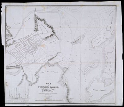
Map of Portland Harbor. Maine Surveyed under the direction of Lt. Col. John Anderson, U.S. Top. Engineer. Drawn by Lieut. B. Poole, 3d Artillery 1833
Collection: Osher Collection
Name: Map of Portland Harbor. Maine Surveyed under the direction of Lt. Col. John Anderson, U.S. Top. Engineer. Drawn by Lieut. B. Poole, 3d Artillery 1833
Barcode: 983
Creator: Poole, Benjamin, -1839
Printmaker: Throop, John Peter Van Ness, approximately 1794-1861
From Atlas: No
Publishing Location: Washington D.C.
Notes: Note: "Engraved by J.V. N. Throop, D.C." From: Report of the survey of Stanford's Ledge, Portland Harbor, Maine, 1832, Congressional Series 259 (23rd Congress, 1st Session) House DocumentIncludes islands, points, coves and other landmarks: Foul Ground; Simonton Cove; Stoney Point; Fort Preble; Black Buoy; Cumming's Point; Stanford's Ledge; Red Buoy; Cumberland and Oxford Canal; Middle Ground; Mount Joy; Back Cove; Presumpscot River; Hog Island Ledge; Little Hog Island; Great Hog Island; House Island; Peakes Island; Banges Island.
Surveyor: Anderson, John
Date/Date Range Produced: 1833
Date/Date Range Published: 1833
Language: English
Region Depicted: Cape Elizabeth, MainePortland Harbor, Maine
Map Type: Nautical charts
Dimensions: H 48.4 x W 55.9 cm
Printing Process: Engraving
Printing Technique: Copper
Material Type: Paper
LC Call Number: TC203 .P55 .P8 1833
OCLC: 55520526
Donor: Osher
Subjects: CoastsIslandsMaine--MapsNautical chartsPortland (Me.)Portland Harbor, Maine
Permenant URL: https://oshermaps.org/map/983.0001