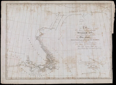
To His Most Excellent Majesty William IVth. King of Great Britain, Ireland, &c., This Chart of the Discoveries made in The Arctic Regions in 1829, 30, 31, 32 & 33. is Dedicated with his Majestys gracious permission by his Majestys Loyal and devoted Subjects John Ross, Captain Royal Navy, James Clark Ross, Commander, Royal Navy
Collection: Osher Collection
Name: To His Most Excellent Majesty William IVth. King of Great Britain, Ireland, &c., This Chart of the Discoveries made in The Arctic Regions in 1829, 30, 31, 32 & 33. is Dedicated with his Majestys gracious permission by his Majestys Loyal and devoted Subjects John Ross, Captain Royal Navy, James Clark Ross, Commander, Royal Navy
Barcode: 994
Creator: Ross, James Clark, Sir, 1800-1862Ross, John, Sir, 1777-1856
From Atlas: No
Publishing Location: Philadelphia
Notes: Detached from: "Narrative of a second voyage in search of a north-west passage and of a residence in the Arctic regions during the years 1829, 1830, 1831, 1832, 1833"
Publisher: Carey & Hart
Date/Date Range Produced: 1835
Date/Date Range Published: 1835
Language: English
Region Depicted: Arctic OceanNorthern CanadaNunavut, Canada
Map Type: GeographicalNautical charts
Dimensions: 42 x 59 cm., folded to 21 x 11 cm.
Printing Process: Engraving
Printing Technique: Copper
Material Type: Paper
LC Call Number: G3270 1833 .R6
OCLC: 55848284
Donor: Osher
Subjects: Arctic OceanArctic regionsCanada, NorthernCarey & HartCoastsNautical chartsNunavut
Permenant URL: https://oshermaps.org/map/994.0001