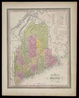
A New Map of Maine by H.S. Tanner
Collection: Osher Collection
Name: A New Map of Maine by H.S. Tanner
Barcode: 1035
Creator: Tanner, Henry Schenck, 1786-1858
From Atlas: Yes
Publishing Location: Philadelphia
Notes: Note: "Entered according to Act of Congress in the year 1840 by H.S. Tanner in the Clerks Office of the Eastern District of Pennsylvania." "6" printed in upper right corner.Top right corner contains information about populations from census data for the years of 1765 - 1840, with each 10 years in between.
Publisher: Tanner, Henry Schenck, 1786-1858
Date/Date Range Produced: 1840
Date/Date Range Published: 1846
Language: English
Region Depicted: Maine
Map Type: GeographicalPolitical maps
Dimensions: H 37 x W 28 cm.
Printing Process: Lithograph
Printing Technique: Planar Surface
Material Type: Paper
LC Call Number:
OCLC: 55519880
Donor: Osher
Subjects: BorderlandsNortheast boundary of the United States
Permenant URL: https://oshermaps.org/map/1035.0001