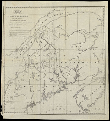
Map of the Northern Part of the State of Maine and of the adjacent British provinces. Shewing the portion of that state to which Great Britain lays claim. Reduced from the official map A with corrections from the latest surveys by S. L. Dashiell. Washington 1830.
Collection: Osher Collection
Name: Map of the Northern Part of the State of Maine and of the adjacent British provinces. Shewing the portion of that state to which Great Britain lays claim. Reduced from the official map A with corrections from the latest surveys by S. L. Dashiell. Washington 1830.
Barcode: 1002
Creator: Anonymous / Unknown Author
Printmaker: T. Moore's Lithography
From Atlas: No
Publishing Location: Washington D.C.
Notes: Note: "T. Moore's Lithog. Boston."
Surveyor: Dashiell, S. L.
Date/Date Range Produced: 1838
Date/Date Range Published: 1838
Language: English
Region Depicted: Bay of FundyCanadaMaineNew BrunswickNova ScotiaSaint Lawrence River
Map Type: Boundary mapsGeographicalPolitical maps
Dimensions: H 46 x W 41.3 cm
Printing Process: Lithograph
Printing Technique: Planar Surface
Material Type: Paper
LC Call Number:
OCLC:
See Also: Map of that portion of Her Majesty's Colonies of New Brunswick and Lower Canada the title to which is disputed by the Government of the U. States with parts of the adjacent country, the Rise and Course of the Rivers, with the direction of the Highlands, and their elevation above the Sea, expressed in English feet, from Barometrical admeasurements, to accompany a report of the investigation of that Country which the Rt. Hone. Viscount Palmerston G.C.B. Her Majesty's Principal Secretary of State, directed to be made A.D. 1839
Donor: Osher
Subjects: BorderlandsCanadaMaineMountainsNew BrunswickNova Scotia (Canada)Rivers and lakesSt. Lawrence RiverT. Moore's Lithography
Permenant URL: https://oshermaps.org/map/1002.0001