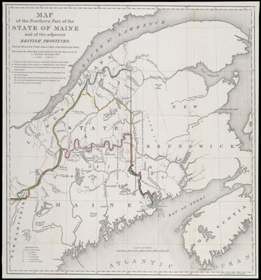
Map of the Northern Part of the State of Maine and of the adjacent British Provinces. Shewing the portion of that State to which Great Britain lays claim. Reduced from the official Map A with corrections from the latest surveys by S.L. Dashiell Washington 1830.
Collection: Osher Collection
Name: Map of the Northern Part of the State of Maine and of the adjacent British Provinces. Shewing the portion of that State to which Great Britain lays claim. Reduced from the official Map A with corrections from the latest surveys by S.L. Dashiell Washington 1830.
Barcode: 1008
Creator: Dashiell, S. L.
Printmaker: Stone, William James, 1798-1865
From Atlas: No
Publishing Location: Washington D.C.
Notes: Note: "W.J. Stone Sc. Wash."
Date/Date Range Produced: 1830
Language: English
Region Depicted: CanadaMaineNew BrunswickNova ScotiaSaint Lawrence River
Map Type: Boundary mapsGeographicalPolitical maps
Dimensions:
Printing Process: Lithograph
Printing Technique: Planar Surface
Material Type: Paper
LC Call Number:
OCLC: 694896666
Donor: Osher
Subjects: BorderlandsNortheast boundary of the United StatesSt. Lawrence River
Permenant URL: https://oshermaps.org/map/1008.0001