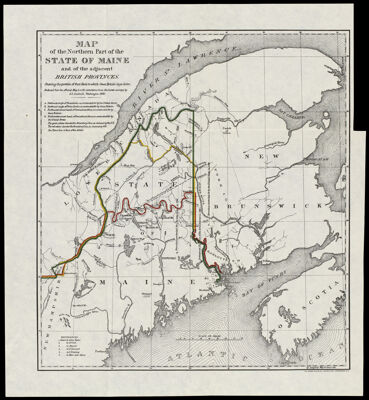
Map of the Northern Part of the State of Maine and of the adjacent British Provinces, Shewing the portion of that State to which Great Britain lays claim. Reduced from the official Map A with corrections from the latest surveys by S.L. Dashiell, Washington 1830.
Collection: Osher Collection
Name: Map of the Northern Part of the State of Maine and of the adjacent British Provinces, Shewing the portion of that State to which Great Britain lays claim. Reduced from the official Map A with corrections from the latest surveys by S.L. Dashiell, Washington 1830.
Barcode: 1297
Creator: Anonymous / Unknown Author
From Atlas: No
Publishing Location: Washington D.C.
Notes: Note below neat line: "The Norris Peters Co., Photo-Litho. Washington, D.C."
Publisher: Norris Peters Co.
Surveyor: Dashiell, S. L.
Date/Date Range Produced: 1830
Date/Date Range Published: 1898
Language: English
Region Depicted: Bay of FundyCanadaMaineNova ScotiaSt. Lawrence River
Map Type: Boundary mapsGeographicalPolitical maps
Dimensions: 28 x 25 cm. on sheet 32 x 29 cm.
Printing Process: Lithograph
Printing Technique: Planar Surface
Material Type: Paper
LC Call Number:
OCLC:
Donor: Osher
Subjects: BorderlandsMaineMaine--MapsMountainsNorris Peters Co.Nova Scotia (Canada)Quebec (Province)Rivers and lakes
Permenant URL: https://oshermaps.org/map/1297.0001