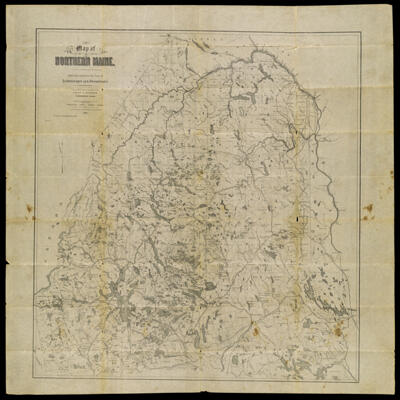
Map of Northern Maine. Specially adapted to the Uses of Lumbermen and Sportsmen Compiled and Published by Lucius L. Hubbard, Cambridge, Mass.
Collection: Osher Collection
Name: Map of Northern Maine. Specially adapted to the Uses of Lumbermen and Sportsmen Compiled and Published by Lucius L. Hubbard, Cambridge, Mass.
Barcode: 1315
Creator: Hubbard, Lucius L. (Lucius Lee), 1849-1933
Printmaker: Meisel, Berthold
From Atlas: No
Publishing Location: Cambridge, MA
Notes: Notes: "Entered according to the act of Congress in the year 1891 by Lucius L. Hubbard in the Office of the Librarian of Congress at Washington, D.C."With envelope: "Hubbard's lumbermen's and tourists' map of northern Maine", third edition. "For sale by E.F. Dillingham, Bangor, Me""B. Meisel Lith. Boston"
Publisher: Hubbard, Lucius L. (Lucius Lee), 1849-1933
Purveyor: Dillingham, E.F.
Date/Date Range Produced: 1900
Date/Date Range Published: 1900
Language: English
Region Depicted: Aroostook County, MainePenobscot County, MainePiscataquis County, MaineSomerset County, Maine
Map Type: Geographical
Dimensions: Map: H 91.5 x W 91 cm
Envelope: H 12 x W 25.5 cm
Printing Process: Lithograph
Printing Technique: Planar Surface
Material Type: Paper
LC Call Number: G3730 .S1 H8 1900
OCLC: 227184851
Donor: Osher
Subjects: Aroostook County (Me.)LakesLumberMaine--MapsMoosehead Lake (Me.)Penobscot County (Me.)Piscataquis County (Me.)RiversSomerset County (Me.)TourismWashington County (Me.)Waterways
Permenant URL: https://oshermaps.org/map/1315.0001; 1315.0002