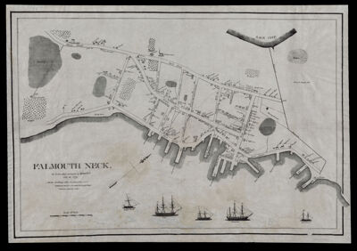
Falmouth Neck, As it was when destroyed by Mowett, Oct. 18, 1775.
Collection: Osher Collection
Name: Falmouth Neck, As it was when destroyed by Mowett, Oct. 18, 1775.
Barcode: 3568
Creator: Willis, William, 1794-1870
From Atlas: No
Publishing Location: Portland, ME
Notes: Note below title: "(All the Buildings within the Dotted line were Destroyed, except a few within the perfect line). Pendleton's Lithography, Boston."
Date/Date Range Produced: 1831
Date/Date Range Published: 1831
Language: English
Region Depicted: Falmouth Neck, MaineMainePortland Harbor, Maine
Map Type: City mapsGeographicalHistorical maps
Dimensions: H 44.4 x W 64 cm
Printing Process: Lithograph
Printing Technique: Planar Surface
Material Type: Paper
LC Call Number: G3731.R3 W5 1831
OCLC: 58436634
Donor: Osher
Subjects: Falmouth (Me.) History Burning by the British, 1775Maine--MapsMowat, Henry, 1734-1798Portland (Me.)Sailing shipsUnited States--History--Revolution, 1775-1783WarshipsWillis, William, 1794-1870
Permenant URL: https://oshermaps.org/map/3568.0001