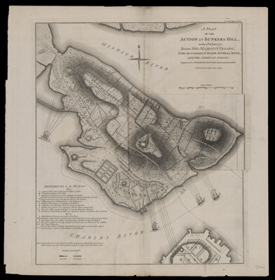
A Plan of the action at Bunkers Hill on the 17th of June 1775 between His Majesty's troops, under command of Major General Howe, and the American forces.
Collection: Osher Collection
Name: A Plan of the action at Bunkers Hill on the 17th of June 1775 between His Majesty's troops, under command of Major General Howe, and the American forces.
Barcode: 47426
Creator: Stedman, Charles, 1753-1812
Notes: From Charles Stedman's "The History of the origin, progress, and termination of the American war." Accompanied by an overlay map labeled "No. 1" which shows the first position of the troops. The map itself is labeled "No. 2".
Date/Date Range Produced: 1793
Date/Date Range Published: 1793
Language: English
Region Depicted: Boston Bay, MassachusettsBoston Harbor, MassachusettsBoston, MassachusettsMassachusettsUnited States
Map Type: Historical mapsPolitical maps
Dimensions:
LC Call Number:
OCLC: 56434528
Donor: Osher
Subjects: American Revolution, 1775-1783United States History Revolution, 1775-1783
Permenant URL: https://oshermaps.org/map/47426.0001