Map of the United States compiled from the most authentic sources.
Collection: Osher Collection
Name: Map of the United States compiled from the most authentic sources.
Barcode: 47471
Creator: Thrall, Willis
From Atlas: No
Publishing Location: Hartford, CT
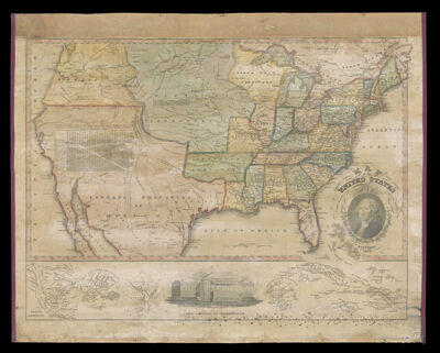
Notes: Shows major cities, areas of Indian habitation by tribe with some statistics, state and territorial boundaries, and the "internal provinces of Mexico". Also includes distances, notes and illustrations with a medallion portrait of George Washington.Bottom of image contains maps: Cuba; Haiti; Jamaica; Boston and its Vicinity; District of Columbia; City of New York and its Vicinity; North America.Bottom also has illustration of the Capital at Washington.
Publisher: Thrall, Willis
Date/Date Range Produced: 1828
Date/Date Range Published: 1828
Language: English
Region Depicted: AlabamaConnecticutDelawareFloridaGeorgiaIllinoisIndianaKentuckyLouisianaMaineMarylandMassachusettsMississippiMissouriNew HampshireNew JerseyNew York (State)North CarolinaOhioPennsylvaniaRhode IslandSouth CarolinaTennesseeUnited StatesVermontVirginiaWest Virginia
Map Type: Wall maps
Dimensions:
LC Call Number: G3700 1828.T5
OCLC: 741311543
Donor: Osher
Subjects: CubaEastern United StatesHaitiIndigenous peopleJamaicaMaps of MexicoNative AmericansNew York (N.Y.)North AmericaUnited StatesUnited States territoriesWashington D.C.Washington, George, 1732-1799
Permenant URL: https://oshermaps.org/map/47471.0001