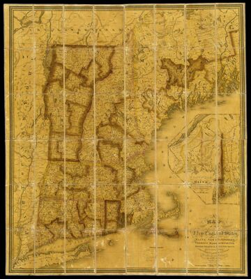
A Map of the New England States Maine New Hampshire Vermont Massachusetts Rhode Island & Connecticut with the adjacent parts of New York & Lower Canada Compiled and Published by Nathan Hale Boston 1826
Collection: Osher Collection
Name: A Map of the New England States Maine New Hampshire Vermont Massachusetts Rhode Island & Connecticut with the adjacent parts of New York & Lower Canada Compiled and Published by Nathan Hale Boston 1826
Barcode: 35858
Creator: Hale, NathanThroop, John Peter Van Ness, approximately 1794-1861
Publisher: Hale, Nathan
Date/Date Range Produced: 1826
Date/Date Range Published: 1826
Language: English
Region Depicted: New England
Dimensions: x
Notes: Sectioned on linen with original slip case [OS-1826-19.2]
Inset map: "North eastern part of Maine and part of Lower Canada and New Brunswick
Note: "Entered according to Act of Congress, the 14th day of August 1826 by Nathan Hale of Massachusetts."
OCLC: 166646743
Accession Number: OS-1826-19.1
Donor: Osher
Permenant URL: https://oshermaps.org/map/35858.0001