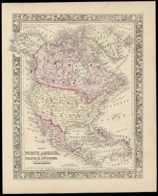
Map of North America Showing its Political Divisions and Recent Discoveries in the Polar regions constructed and engraved by W. Williams
Collection: Osher Collection
Name: Map of North America Showing its Political Divisions and Recent Discoveries in the Polar regions constructed and engraved by W. Williams
Barcode: 3642
Creator: Williams, W. (Wellington)
Printmaker: Williams, W. (Wellington)
Publishing Location: Philadelphia
Notes: Note: "Entered according to Act of Congress in the year 1860 by S. Augustus Mitchell, Jr. in the Clerks Office of the District Court of the U.S. for the Eastern District of Pennsylvania"Above neat line right corner: No. "3"Note: "Constructed and Engraved by W. Williams Philadelphia."Shows major cities, political divisions including Russian America, Danish America, British America, and Central America.From "Mitchell's General Atlas"
Publisher: Mitchell, S. Augustus, Jr. (Samuel Augustus)
Date/Date Range Produced: 1860
Date/Date Range Published: 1860
Language: English
Dimensions: H 39.1 x W 31.5 cm
LC Call Number: G3300 .W5 1860
OCLC: 70868078
Donor: Osher
Permenant URL: https://oshermaps.org/map/3642.0001