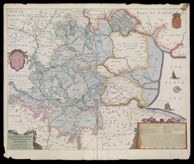
A general plott and description of the Fennes and surrounded grounds in the sixe counties of Norfolke, Suffolke, Cambridge, with in the Isle of Ely, Huntington, Northampton and Lincolne, etc.
Collection: Smith Collection
Name: A general plott and description of the Fennes and surrounded grounds in the sixe counties of Norfolke, Suffolke, Cambridge, with in the Isle of Ely, Huntington, Northampton and Lincolne, etc.
Barcode: 1715
Creator: Hondius, Hendrik, 1597-1651
From Atlas: Yes
Publishing Location: Amsterdam
Notes: Note lower left: "Amstelodami, Sumptibus Henrici Hondii. 1632." English edition. Dedication in Latin.
Publisher: Hondius, Hendrik, 1597-1651
Date/Date Range Produced: 1632
Date/Date Range Published: 1632
Language: English
Region Depicted: Cambridgeshire, EnglandEastern EnglandHuntingdonshire, EnglandIsle of Ely, EnglandNorfolk, EnglandSuffolk, EnglandThe Fens, England
Map Type: Geographical
Dimensions: H 48.7 x W 58 cm
Printing Process: Engraving
Printing Technique: Copper
Material Type: Paper
LC Call Number: G5754 .H6 1632
OCLC: 80018198
Donor: Smith
Subjects: Agricultural implementsAgricultureCambridgeshire, EnglandCartouches, Ornamental (Decorative arts)Devices (Heraldry)England, EasternFens, The (England)FruitHeraldryHuntingdonshire, EnglandIsle of Ely (England)Norfolk, EnglandplantsSailing shipsSuffolk, EnglandToolsVegetables
Permenant URL: https://oshermaps.org/map/1715.0001; 1715.0002