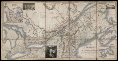
Map of Provinces of Lower and Upper Canada, Nova Scotia, New Brunswick, Newfoundland, & Prince Edward Island, with a large portion of the United States, Compiled from the latest and most approved Astronomical observations, authorities, and recent surveys, is with His Majesty's most gracious & special permission, most humbly & gratefully dedicated by His Majesty's most devoted & Loyal Subject. Joseph Bouchette Junr. Deputy Surveyor of the Province of Lower Canada.
Collection: Osher Collection
Name: Map of Provinces of Lower and Upper Canada, Nova Scotia, New Brunswick, Newfoundland, & Prince Edward Island, with a large portion of the United States, Compiled from the latest and most approved Astronomical observations, authorities, and recent surveys, is with His Majesty's most gracious & special permission, most humbly & gratefully dedicated by His Majesty's most devoted & Loyal Subject. Joseph Bouchette Junr. Deputy Surveyor of the Province of Lower Canada.
Barcode: 11891
Creator: Bouchette, Joseph, 1800-1881
From Atlas: No
Notes: Note above map title: "To his most excellent Majesty King William Ivth." Note below map: " Published as the Act directs by James Wyld, Geographer to the King Charing Cross London, May 2nd, 1831." Map is linen-backed.
Publisher: Wyld, James, 1812-1887
Date/Date Range Produced: 1839
Date/Date Range Published: 1839
Language: English
Region Depicted: CanadaNew EnglandNewfoundland and LabradorNova ScotiaPrince Edward Island, Canada
Map Type: GeographicalPolitical maps
Dimensions: H 99 x W 188 cm
Printing Process: Engraving
Printing Technique: Copper
Material Type: Paper
LC Call Number:
OCLC:
Donor: Osher
Permenant URL: https://oshermaps.org/map/11891.0001