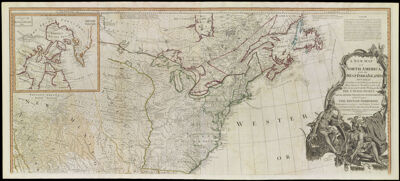
A New Map of North America, with the West India Islands. Divided according to the preliminary Articles of Peace, signed at Versailles, 20, Jan. 1783. wherein are particularly distinguished the United States, and the several provinces, governments & ca. which compose the British Dominions, laid down according to the latest surveys, and corrected from the original materials, of Governor Pownall, Member of Parlaiment
Collection: Osher Collection
Name: A New Map of North America, with the West India Islands. Divided according to the preliminary Articles of Peace, signed at Versailles, 20, Jan. 1783. wherein are particularly distinguished the United States, and the several provinces, governments & ca. which compose the British Dominions, laid down according to the latest surveys, and corrected from the original materials, of Governor Pownall, Member of Parlaiment
Barcode: 11966
Creator: Bowen, Emanuel, 1693 or 1694-1767Gibson, J. (John), active 1750-1792
Notes: 1 map on 2 sheetsInset maps titled: "A Particular Map of Boffin and Hudson's Bay" and "The Passage of Land to California" Note: "London. Published by Laurie & Whittle, No. 53, Fleet Street. 12th May 1794."Decorative cartouche featuring pictures of Native Americans
Date/Date Range Produced: 1783
Date/Date Range Published: 1783
Language: English
Dimensions: 78 cm. x 226 cm.
Printing Process: Engraving
Printing Technique: Copper
Material Type: Paper
LC Call Number:
OCLC:
Donor: Osher
Permenant URL: https://oshermaps.org/map/11966.0001; 11966.0002; 11966.0003