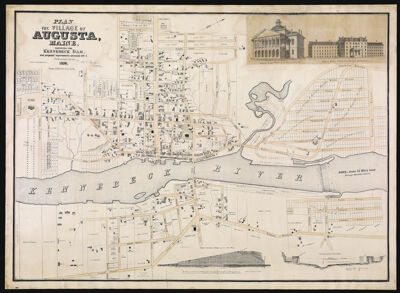
Plan of the Village of Augusta Maine, shewing the Kennebeck Dam, and proposed improvements connected with it. From actual survey by B.F. Perham Civil Engineer 51 Court St. Boston. 1838.
Collection: Osher Collection
Name: Plan of the Village of Augusta Maine, shewing the Kennebeck Dam, and proposed improvements connected with it. From actual survey by B.F. Perham Civil Engineer 51 Court St. Boston. 1838.
Barcode: 37548
Creator: Perham, Benjamin Franklin
Notes: First published map of Augusta.Lithographed city plan.Partial cadastral map showing buildings and property boundaries with names of property owners, proposed canals, and lands of the Kennebec Lock & Canal Co.Oriented with north toward the upper right.Includes 2 profiles: Cross section of dam from C to D on plan. Scale [1:180] -- Section A to B on plan. Scale [1:1,200]. Horizontal scale [1:600]; and 2 ill.: North east view of the State House -- North west view of the insane hospital.
Date/Date Range Produced: 1838
Date/Date Range Published: 1838
Language: English
Dimensions: x
LC Call Number: G3734.A9 1838 .P4
OCLC: 57271734
Donor: Osher
Permenant URL: https://oshermaps.org/map/37548.0001