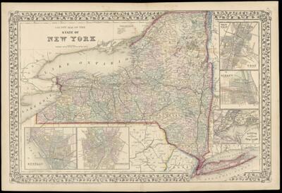
County Map of the State of New York drawn and engraved by W.H. Gamble
Collection: Story Collection
Name: County Map of the State of New York drawn and engraved by W.H. Gamble
Barcode: 2297
Creator: Gamble, W. H. (William H.)
Printmaker: Gamble, W. H. (William H.)
Publisher: Mitchell, S. Augustus, Jr. (Samuel Augustus)
Date/Date Range Produced: 1867
Language: English
Dimensions: 35 x 50
Notes: Also shows railroad lines.
Note: "Entered according to Act of Congress in the year 1867 by S. Augustus Mitchell Jr."
Map within decorative border
Inset maps: "Buffalo" "Rochester" "Troy" "Albany" "Harbor and Vicinity of New York"
Atlas plate no. "18"
LC Call Number: G3801.F7|.M5 1867
OCLC: 46836138
Accession Number: ST-1867-10
Donor: Story
Permenant URL: https://oshermaps.org/map/2297.0001