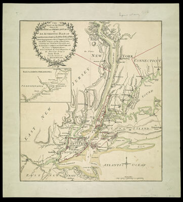
The Seat of Action, between the British and American Forces. or An Authentic Plan of the Western Part of Long Island, with the Engagement of the 27th August 1776, between the Kings Forces and the Americans: containing also Staten Island, and the Environs of Amboy and New York, with the course of Hudsons River, from Courtland the Great Magazine of the American Army, to Sandy Hook. from the surveys of Major Holland
Collection: Smith Collection
Name: The Seat of Action, between the British and American Forces. or An Authentic Plan of the Western Part of Long Island, with the Engagement of the 27th August 1776, between the Kings Forces and the Americans: containing also Staten Island, and the Environs of Amboy and New York, with the course of Hudsons River, from Courtland the Great Magazine of the American Army, to Sandy Hook. from the surveys of Major Holland
Barcode: 1989
Creator: Holland, Samuel, 1728-1801
Date/Date Range Produced: 1776
Date/Date Range Published: 1776
Language: English
Dimensions: 44 x 39
Printing Process: Engraving
Printing Technique: Copper
Material Type: Paper
Notes: Inset map: "Road from Amboy to Philadelphia"
Handwritten notations on map of the location of General von Knyphausen on October 22, 1776. Wilhelm, baron von Knyphausen commanded Hessian troops on the British side in the American Revolution.
LC Call Number: G3802 .H6 1776
OCLC: 180086381
Accession Number: SM-1776-18
Donor: Smith
Permenant URL: https://oshermaps.org/map/1989.0001