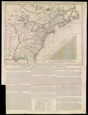
The Theatre of War in North America, with the Roads and A Table of the Distances.
Collection: Smith Collection
Name: The Theatre of War in North America, with the Roads and A Table of the Distances.
Barcode: 1991
From Atlas: No
Notes: 1 map: colored, illustrated. Includes text titled: "Evan's Polymetric Table of America," "A Compendious Account of the British Colonies in North-America," and "A Table of the Population of the British Colonies in North-America, published in New-Jersey, in November, 1765."
Publisher: Robert Sayer and John Bennett (Firm)
Date/Date Range Produced: 1776
Date/Date Range Published: 1776
Language: English
Region Depicted: Eastern United States
Map Type: GeographicalPolitical mapsThematic maps
Dimensions: H 74.5 x W 55.5 cm
Printing Process: Engraving
Printing Technique: Copper
Material Type: Paper
LC Call Number: G3300 .T5 1776
OCLC: 180086956
Donor: Smith
Subjects: Canada, EasternColonial AmericaConnecticutDelawareEast (U.S.)FloridaGeorgiaGreat Lakes (North America)MaineMarylandMassachusettsMiddle Atlantic StatesNative American tribesNew EnglandNew HampshireNew JerseyNew York (State)Newfoundland and LabradorNorth CarolinaNova Scotia (Canada)OntarioPennsylvaniaQuebec (Province)Rhode IslandRobert Sayer and John Bennett (Firm)South Atlantic StatesSouth CarolinaUnited States History Revolution, 1775-1783VermontVirginia
Permenant URL: https://oshermaps.org/map/1991.0001